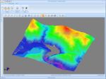
MDT in Chinese
Continuing the policy of international expansion APLITOP, we announced the availability of MDT 6.5 in Chinese. Previously it was delivered in Spanish, English, European Portuguese, Brazilian Portuguese and Basque. Besides translation, there have been some adjustments to the presentation styles and road regulations used in China, having had the col ...