


GPS/GNSS receiver
Use your mobile device for data collection or stakeout and work in all kind of surveying and civil projects.
Surveying the Future
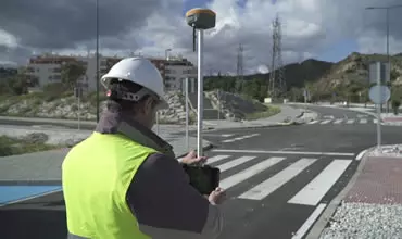
Easily perform all types of data capture, survey and stakeout work using GPS/GNSS receivers.

Complete solution in CAD, which allows you to model the terrain of a plot of land to elaborate road or urbanization projects.
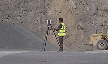
Use point clouds from scanner, LiDAR or photogrammetry, as well as orthophotos, digital elevation models and aerial images in your projects.
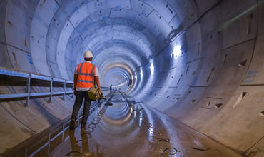
Execute easily and accurately the construction of tunnels for roads, railroads, subways and mines, with total station or 3D scanner.
In Aplitop, we offer tailored solutions to various sectors, such as water and energy, cadastre, building, civil engineering, environment, and many others.


Because I use it all the time and it is my working tool.
Freelancer
Simple, intuitive application, very pleasant to work with. Excellent support.
The best aspect of the agreement for the application is the great attitude of the technical support staff. They are diligent and worked quickly to resolve all the challenges we have raised to date.
Very useful and easy to learn how to use.
Diedro Análisis Técnicos, S.L.
Technical support is very good, precise and quick responses about tcpScancyr and tcpTUNNEL.
I am very happy with the product, but especially with the excellent service and quick response to the issues and questions raised.
The route of the new Ottawa Light Rail runs underground for 2,533 meters through the city center. There are three stations: Lyon (West), Parliament (East) and Rideau. As per contract, its scope is not limited to the design and construction of the infrastructure but also the maintenance for 30 years of the 12,5 km of the Confederation line.
View details
APLITOP S.L. has been a beneficiary of the European Regional Development Fund whose objective is to improve the use and quality of information and communication technologies and access to them and thanks to which it has optimized our commercial processes for the improvement of competitiveness and productivity of the company 2022. For this, it has had the support of the INNOCAMARA PROGRAM of the Chamber of Commerce of Malaga. "A way of making Europe".
APLITOP S.L. has benefited from the INTERNATIONAL MENTORING Programme to improve and consolidate its international positioning through the implementation of an International Action Plan. The programme is financed by European Next Generation-EU funds, as part of the Recovery, Transformation and Resilience Plan.
Midiendo el futuro con sostenibilidad. Implementamos medidas responsables para reducir las emisiones de CO₂ el desarrollo de nuestras soluciones