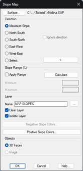
With this process, the different slopes contained in a surface (terrain) can be analyzed. By default, the current active surface is selected in MDT, but you can change the study surface by pressing the Surface button.
In the Orientation section, specify the direction in which the slopes are to be calculated in each of the triangles on the surface:
Maximum Slope: For each triangle, the orientation of the maximum slope is calculated, and the absolute value of that slope is considered for the representation. In this case, the slope map would have a hydrological application, rather than to determine the suitability of the land for use as a solar production facility.
North-South: for each of the triangles, the slope is calculated from north to south, and can give a negative result if the terrain goes down, or a positive result if the terrain rises as it "moves" along the triangle. If the Ignore direction option is activated, the absolute value of the slope is used, so there would be no difference between North-South mode and South-North mode.
South-North: complementary to the previous option.
East-West: For each of the triangles, the slope is calculated from east to west. If you activate the Ignore direction option, there is no difference between this mode and the West-East mode.
West-East: complementary to the previous option.
Select: This option allows you to designate any orientation.
Once the orientation to be used has been established, in the Slope Range section, you can click on the Calculate button so that the program can make a first analysis of the range of slopes present on the surface. By activating the Apply Range option, you can restrict the range of slopes to be represented, in case you prefer not to represent the entire range of slopes.
In addition to choosing which CAD layer the map is represented on, with the corresponding buttons, you can assign different color palettes to the positive and negative slope ranges. In case the selected orientation only calculates slopes in absolute value, the button for the colors of the negative slopes will be disabled.
Finally, you can choose to render the map with CAD 3D Face features, or create a raster image.