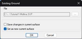
This command allows you to set the surface that is used as the initial terrain or existing ground of the project. This surface will be used for the calculation of cut and embankment volumes of the project, as well as serve as the basis for making the final surface of the project.
Optionally, you can also set the surface selected here as the current MDT surface. If a current surface already exists in MDT, you can save the changes to the surface that have yet to be saved by activating the corresponding option before switching to the new current surface.