This command is used to invert a grade line file. The process is performed by inverting the vertex stations, maintaining the same distance between them and leaving the transition’s curves values unchanged. An example of running this command is shown below.
Original grade line:
0.000
540.062
0.000
0.000
0.000
177.763
563.330
55.000
7.901
0.567
302.571
543.810
300.000
40.962
2.796
870.839
610.115
0.000
0.000
0.000
Inverted grade line:
0.000
610.115
0.000
0.000
0.000
568.268
543.810
300.000
40.962
2.796
693.076
563.330
55.000
7.901
0.567
870.839
540.062
0.000
0.000
0.000
Review Grade Line
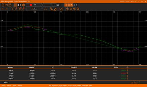
This application allow us to edit and visualize a vertical alignment (ras file) and to also visualize the terrain’s longitudinal profile (lon file) as reference.
Once we run the application, we’ll see something similar to this:
Along this document we are going to detail each of the parts, as a general overview we can distinguish multiple sections in the application’s interface:
·Title bar: At the top, the orange bar. The application’s title appears at the left side. To the right we can find some options: Settings, Help and About us. Further to the right we have the usual window’s controls: minimize, maximize/restore and close.
·Toolbar: Just under the title bar. It allow us to manage the state of the view and to access to all the different edition tools.
·CAD View: The application provides a CAD view in which the vertical alignment will be represented as polylines, it also allow us to take measures.
·Vertical Alignment’s Panel: Under the CAD view we can see a panel with the active vertical alignment’s information.
·Status bar: At the window’s bottom, the orange bar. It provide us with general information as: the cursor coordinates in the drawing, the vertical alignment’s height and (if there’s a longitudinal loaded) the terrain’s height and height difference. It’ll show also information messages during the edition commands