Allows the conversion and/or transformation of coordinates supplied in manual mode or read from file.
To make the calculations you have to indicate the parameters for reference systems 1 (CRS 1) and 2 (CRS 2) (See section Coordinate System Configuration), enter the coordinates, and click the button , to convert from CRS 1 to CRS 2 or , to make the conversion in the other direction.
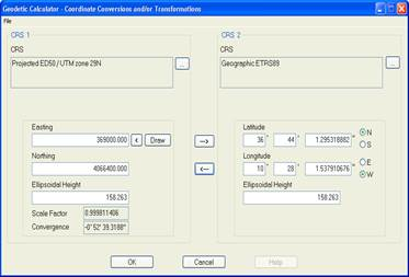
Depending on the type of geodetic CRS established, the following names are displayed for the coordinate axes:
Geographic CRS
Latitude
Longitude
Geocentric CRS
X
Y
Z
Projected CRS
East
North
For geographic and projected CRS’s, Orthometric Altitude or Ellipsoidal Altitude will be displayed, depending on whether or not Vertical CRS has been selected.
For projected reference systems, Convergence of meridians, in degrees, minutes and seconds, and the Scale Factor are displayed as additional information. In addition, you can select coordinates from the drawing by clicking the < button, and draw calculated coordinates by clicking Draw…