The menu File > CRS configuration lets you Open default settings and Save the present configuration of the calculator. Unlike as explained in the section Coordinate System Configuration, opening and saving operations are performed on the source and target systems and not just on one of them.
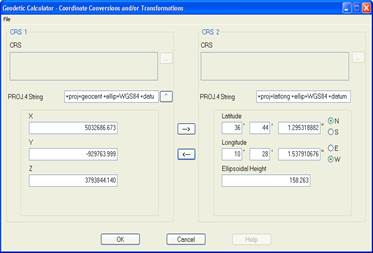
Another use of STS files in this option is to enable the calculator to work directly with PROJ.4 strings. The format has to be as follows:
PROJ4
String_PROJ4_Source
TO
String_PROJ4_Target
Example:
PROJ4
+proj=geocent +ellip=WGS84 +datum=WGS84
TO
+proj=latlong +ellip=WGS84 +datum=WGS84
The path of files used with the option “+nadgrids” cannot contain blank spaces. These must be replaced by the character ‘|’.
Example : +nadgrids=c:\configuration |files\file.gsb
In this way two boxes are enabled, one in CRS 1 and another in CRS 2, in which, initially, the strings read from the file appear and which can then be modified manually.
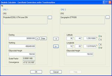
The program automatically detects the type of geodetic CRS and establishes the corresponding boxes for the CRS 1 and CRS 2 coordinates.
To perform the conversions and/or transformations you have to enter the coordinates and click the or button, the same as in the default mode of operation.
The button , which appears to the right of the Cadena PROJ.4 box of the CRS 1, disables this calculator mode.