The central part of the dialog box contains a list of the possible station coordinates that displays information about their origin and the calculation method used. These allow one to have an overview of the magnitude of the errors and reminds one how the calculation process was executed. The current coordinates of the station are the ones selected in this list.
The list’s first field, Observation St., displays which station allowed the calculation of the current station. The last field called Observations shows the method, which could be any of the following:
Name
Description
Direct Assignment
Coordinates assigned directly to the station
Database
Coordinates obtained from an imported stations file
Change Coord.
Change of coordinates
Compensation
Network compensations
Drawing
Coordinates obtained from drawn stations
Direct Int.
Direct Intersection
Inverse Int.
Inverse Intersection
Double Observation
Station calculation using forward and backward observations
Simple Observation
Station calculation using one-way measurements only
Traverse
Traverse compensation
Average
Coordinate averaging
UTM transformation
Plane to UTM coordinate transformation
In addition to these observations, the text “and Levelling” may appear after the code. This indicates that the X and Y station coordinates have been calculated by one method, and the elevation calculated by levelling. This gives one a great deal of control over the way in which the calculations have been performed.
Below the list of possible station coordinates, the program indicates the maximum distance errors (eD), and coordinate errors (eX, eY and eZ). These values are the maximum differences between all the alternatives for any station.
Clicking the Average button assigns the station an average value from all the possible station coordinates. If one wishes to delete any of the possibilities, Delete should be clicked. For example, if they are considered to be unreliable. If one wishes to delete all of them for any station, Delete All should be clicked.
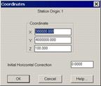
Lastly, the Assign button allows one to directly input coordinates and the initial instrument set-up’s initial horizontal correction.