This mode can be used to calculate points and stations, and additionally gives access to other calculation methods and more advanced options.
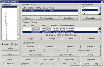
Origin Station. Allows one to select the station of origin. Once selected, the dialog box displays the instrument set-ups at this station, the stations and points read, as well as the coordinates calculated.
Origin. When this check box is activated, it indicates that the station should be considered as an origin in order to automatically calculate stations and points by clicking the appropriate button. See Automatic Calculation.
Fixed. If this option is activated, the station’s coordinates will not be modified whichever calculation method used.
Delete. Deletes the origin station from the survey file. All the associated observations are also deleted, so confirmation is requested before this action can take place.
Sort. Modifies the representation order of the origin stations. It can be in alphabetical or numerical order, and the original file order is lost.
Coords. Allows access to the Station Coordinates information.
Projected. Activating this option indicates that the survey is not using plane coordinates, but one of the projections permitted by the application. See Survey Data command.
The options set out below can be found in the Instrument Set-Up box:
Instr.Set-Up. Allows access to Instrument Set-Up information.
Point Observations. Allows access to the Points Observations information.
Coordinates. Allows access to the Point Coordinate information.
The following options can be found within the Target Station box:
Stations. Displays a list of the stations read from the origin station. Double clicking on New allows one to enter an new station observation from that base station.
Observations. Allows access to the Station Observations information.
The Calculated Coordinates box displays the coordinates calculated from the station of origin. See Calculated Coordinates. See Calculated Coordinates.
The following options are available in the Calculation Methods box:
Automatic. See Automatic Calculation.
Traverses. See Traverses.
Networks. See Networks.
Average All. The Average All button averages all coordinates at each station in a similar way as the Average button.
Manual. See Manual Calculation.
Orient. Clicking this button causes the program to assign a horizontal correction to the actual instrument set-up. This correction is calculated from the origin and target station coordinates.
Inverse Bisection. See Inverse Bisection.
Inverse Intersection. See Inverse Intersection.
Direct Intersection. See Direct Intersection.
Leveling. See Trigonometric Leveling.
Some additional buttons are to be found at the bottom of the dialog box:
Survey. See Survey Data command.
Draw Stations. Draws the stations and their observations. See Draw Stations and Draw Station Observation commands.
Draw Points. See Draw Points command.
Configuration. Allows access to the Surveying Configuration.
Lastly, there is a status line displaying the state of the corrections used on the bottom line of the dialog box, so that they can be easily consulted. The initials of those that are activated will be displayed as enabled, among the following:
|
Code
|
Description
|
|
ATM
|
Atmospheric
|
|
ESR
|
Sphericity and Refraction
|
|
RHO
|
Reduction to Horizon
|
|
RNM
|
Reduction to Sea Level
|
|
ELP
|
Reduction to Ellipsoid
|
|
AAP
|
Instrument Angle
|