By clicking the Automatic button in the Station Calculation command, the program calculates the whole survey using various methods. For this to be possible, the measurements must be taken from a station having assigned coordinates and marked as an origin.
The following algorithm is used:
· First, the program examines all the instrument set-ups containing direct circle and inverse circle observations, so as to assign the angle corrections due to the instrument accuracy (CH.Ap and CV.AP).
· Then starting with the current instrument set-up and following the order in which the files appeared, all the stations containing return (there and back) observations are calculated.
· Subsequently, all the one-way observation stations are calculated in the same order as above.
· For stations that could not be calculated as above, the direct intersection method and then the inverse intersection method are attempted.
· The process is repeated until all stations have been calculated, or until no more can be calculated from the available data.
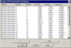
Once the process is completed, the program displays an on-screen report showing the errors obtained.
This window displays the calculation method used, the target and origin stations, distance errors, as well as the height and angle obtained . An asterisk to the right of the value indicates that it falls beyond the configuration tolerance set. If a line from the list is selected and Edit clicked or if the line is double clicked, the program displays the observations between stations and allows one to modify them.