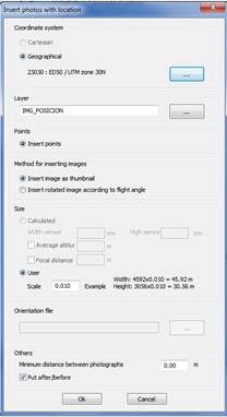
This command allows a group of images with EXIF(1) information about their location to be selected and shows a dialogue in which a choice can be made between inserting a point with a hyperlink to the image or inserting the image in miniature on the scale chosen by the user at said location.
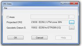
Those options which are common to both insertion methods are: insert points with a hyperlink, only images or both, select the appropriate coordinates reference system for converting the information taken from the EXIF labels for geographic coordinates (latitude, longitude, altitude) into projected coordinates (X, Y, Z) by pressing the browse button, choose the minimum distance between photos, their placement with regard to the drawing, in other words, in front of or behind the latter and the choice of layer. In order to able to open the hyperlink of the points inserted, go to Points >Open hyperlink, select the point and the image will be shown in the application predetermined in the system for opening images.
The specific options for the method to insert an image as thumbnail are: in the Size section, we can only choose the manual option and enter a scale value for which an example is shown with the height and width of one of the images selected so we can get some idea of the size of the image inserted.
The specific options for the method to insert an image turned according to the angle of flight are: the orientation information for these images may be shown on the EXIF labels or in a text file which can be selected in the section Orientations file which may come under Cartesian coordinates (x, y, z) or under Geographic coordinates (latitude, longitude and altitude), information which the user must be familiar with and select the corresponding option in the section Coordinate System in the event that the orientation information cones in a file, the user must also provide the focal distance of the camera. In the Size section a choice can be made between Calculated, whereby the scale is calculated based on the side of the sensor an the focal distance or Manual whereby it is the user who enters the desired scale value; this section also contains the Average Altitude field and it is used so that the user can insert a mean altitude value and so that the real altitude values of the images are not taken into account.
(1) EXIF “Exchangeable Image File Format” is a standardization of the information about the image format. The EXIF information is in the same file: structure, size, encoding, date of creation, position, focal, amongst many other attributes. This standardization allows the different digital cameras and smartphones to record this information in the images so that it can subsequently be read and interpreted numerous software and scripts for image handling. In the specific case of information about location, this can only be added by those devices with GPS integrated.