The OpenGis consortium http://www.opengis.org has developed a protocol to obtain geographic information by means of the Internet and a multitude of public and private organizations have services of this type. This command allows connection to one of these services, downloading one or several images and inserting them in the current CAD drawing at the appropriate coordinates.
OGC’s WMTS (Web Map Tile Service) provides a complementary approach to the WMS (Web Map Service); WMTS uses a parameterized tile model in such a way that clients can make requests for a discrete set of values and receive tiles quickly from the server. Each of the layers of a WMTS server follows one or several pyramidal structures of scales, in which each scale or level of the pyramid is a regular rasterization and fragmentation of the geographic data of a specific pixel scale or size. Therefore, only one layer can be selected, unlike WMS where you can select all the layers you want.
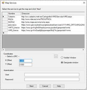
Firstly, a window appears with a list containing the different maps’ services configured in the program. This list includes a Name to identify the service and a website Link where the map request can be made. Elements can be added to the list, typing on the line marked *. Furthermore, the drawing projection must be specified and whether it is wished to obtain an image which takes up the whole visible drawing area or designate a smaller window.
WMS-T Services: Some of the map services now provide the possibility of specifying the desired reference date for importing the map. This type of parameter is specific to each provider. The user may specify this parameter at the corresponding address. There follows an example in which the user accesses the Spanish Cadaster website for a specific date.
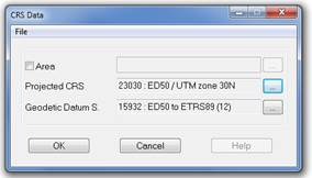
To select the drawing projected, the examine button must be pressed and it will show us the following dialogue:
When the service requires basic authentication, you can enter your Username and Password to access the service which will be coded and stored for later use.
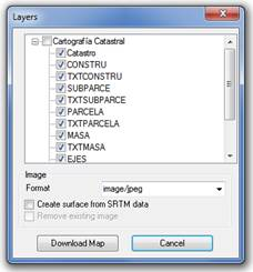
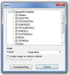
By pressing the Next button, the program connects to the service selected on the list and another window appears to select the layers to be included in the image as well as the format of the latter. These options depend on the service selected.
If there is a surface on the drawing, the possible dialogue options will be: Assign Image as surface material, if we activate this option the program is enabled to show this image in the commands Field Route, Road Route and ¡Error! No se encuentra el origen de la referencia.. The option Remove Existing Image is enabled in the event that the drawing has already inserted an image. By activating it, a previous image may be easily replaced by another in the event of executing the command more than once.
In the event that there is no surface in the drawing, the option Assign Image surface material is replaced by Create surface with SRTM data (2) and upon activating this option, the Internet will be connected to obtain the information required to create the surface of NASA’s SRTM mission (http://www2.jpl.nasa.gov/srtm/). The option Remove Existing Image will appear deactivated.
When the selected service is WMTS, you can select a different resolution to the one calculated from the designated window and the drawing zoom, the list of resolutions will depend on the selected layer. To do this in the Resolution box you can put in the desired value.
You can give a name to the downloaded file and choose the location, by pressing the corresponding button.
By pressing the Download Map button, the image requests start and finally the program will request a file where to save it. A second file will be created automatically with the georeferencing data of the image and the image will be inserted in the drawing.
To consult the list of WMS services available in Spain, consult the following web page: http://www.idee.es. In other countries refer to mapping authorities.
When downloading an image from the cadaster where some layers have been selected, such as that of the cadaster, alignments, parcels, … the result could be as follows:
It may sometimes be impossible to download the map as there is no Internet connection for foreign countries; this may occur on local or corporate networks where the Internet connection is controlled by a username and password system. As such, if the command is unable to download the map because there is no Internet connection, it will request the username and password in a new window, so, in the event it exists, the user can insert the corresponding data.
(2) The SRTM “Shuttle Radar Topography Mission” consists of an especially modified radar system which was flown on board the space shuttle Endeavour to acquire stereoscopic topographic elevation data. Elevation models deriving from SRTM data is used with GIS (Geographic Information System) software which may be accessed free-of-charge online and whose extension (.hgt) is supported by many software programs.