This command will allow us to edit the characteristics of a certain zone. When we execute it, we will You will request the graphic designation of the zone, it is possible to designate the polyline or the name associated with it.
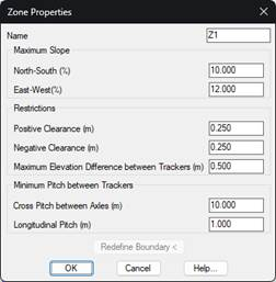
Next, the following window will appear with the properties described below.
Name: Name of the zone, if we assign a new one, it will be automatically updated in the drawing.
Maximum Slopes. North–South (%): We indicate the maximum North-South slope that trackers can have. The absolute value is considered. If the tracker's slope is greater than this value, the tracker will be considered as erroneous per slope.
Maximum Slopes. East-West (%): The maximum East-West or transverse slope that can exist between contiguous trackers is specified.
Positive Clearance (m): A Positive Clearance value for all trackers in the zone.
Negative Clearance (m) - Negative Clearance value for all trackers in the area. It is specified in absolute value.
Maximum Elevation. Difference between Trackers (m): Maximum permissible difference in elevation between two consecutive North-South trackers.
Cross Pitch between Axles (m): Maximum cross-sectional difference between trackers.
Longitudinal Pitch (m): Maximum longitudinal difference between the north-south trackers.
Redefine Boundary: With this button you can define a new boundary for the edited area.