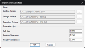
This command allows you to create the implementing surface for a zone. This surface represents the areas of clearing and embankment that must be executed on the natural terrain to obtain a terrain that allows the placement of the trackers of the zone.
As input surfaces, you need the natural or existing terrain (by default, the initial terrain of the project) and the design surface of the zone. The result of the command execution is the corresponding implementing surface, which is automatically assigned a default name.
The parameters involved in the surface calculation are similar to those involved in the volume calculation:
Cell Dimension: Horizontal distance to create the regular meshes that will represent the cut and fill areas. The smaller this value, the more accurate and slower the calculation.
Positive Clearance: permissible vertical distance between the natural terrain and the design surface when the latter is higher. The higher the positive clearance, the lower the fill volume.
Negative Clearance: permissible vertical distance between the natural terrain and the design surface when the latter is lower. The higher the negative clearance, the lower the volume of clearance.
Finally, a warning will appear on the command line indicating the number of triangles contained in the created surface.
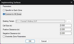
Similar to creating design surfaces, if you select the Multiple (or All) option at the beginning of the command, you can recalculate multiple surfaces at once.