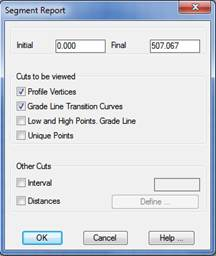
Once a segment file has been selected, the program displays the following window:
This dialog box configures the type of list one wishes to obtain. Each of the controls making it up are described below.
Initial and Final Station: The station interval one wishes to obtain is set here. First the initial and final stations of the longitudinal profile comprising the segment are assigned (see definition of Segment in the Horizontal Alignments section).
Cuts to be Viewed: The characteristic points of the longitudinal profile, the grade line or the horizontal alignment one wishes to list are selected.
· Longitudinal Vertices: All the vertices comprising the profile are listed.
· Grade Line Transition Curves: The grade line’s transition curves are listed, in other words, the entry and exit tangents, as well as the vertex.
· Low and High points, Grade Line: A list is provided of the stations featuring the maximum and minimum heights on the vertical alignment curves.
· Unique Points: The characteristic points of the horizontal alignment the segment selected contains are listed.
Other Cuts: In this section, other cuts are entered that the user may be interested in seeing on the list.
Interval: Depending on the value entered, MDT will represent the longitudinal profile’s cuts using this value as an interval. The cut height will be interpolated between the previous and next vertices.
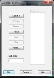
Distances: If this button is activated, a dialog box will be displayed, where the specific distances one wishes to list are entered. They can either be typed in with the keyboard or selected graphically. The dialog box displayed when this button is clicked appears below.
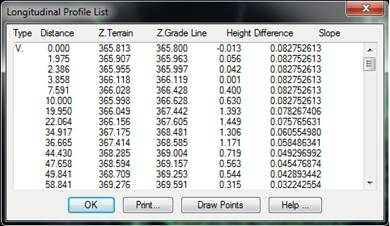
Once the main dialog box has been validated, the following list appears. It shows the characteristics listed below for each cut.
Type: Indicates the characteristics of the cut or interval’s:
U.P.: Horizontal alignment’s unique point.
V.: Grade line transition curve’s vertex.
I.T.: Grade line’s input tangent.
O.T.: Grade line’s output tangent.
Distance: Indicates the longitudinal profile’s distance to origin.
Terrain Z.: Represents the terrain’s height.
Grade line Z.: Represents the grade line’s height.
Height Diff.: Represents the height difference between the terrain and the grade line, with a sign.
Slope: Represents the grade line’s slope.
The following additional buttons also exist:
Print: Sends the list to the Windows default printer.
Excel: Sends the information to an Excel spreadsheet.