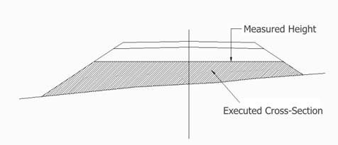
This command is of great use, since it allows one to rapidly calculate the quantity and percentage of the work executed from a file of points taken from the platform. These points do not have to coincide with stations, since the program interpolates the rest of the information. For each profile, it estimates the percentage executed from the cutting and fill heights.
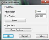
The program initially requests the Segment containing the complete road information, requesting the roadbed layer for which to make the calculation whenever a roadbed layer definition exists in the selected segment. Next the following dialog box is displayed for entering the rest of the parameters for the calculation:
Initial Station: Initial station from which the calculation is made.
Final Station: Station up to which the calculation is made.
Points: Points file taken from the current state of the works.
Cross-sections: Cross-sections file where the program will save the current state of the works. MDT will analyze the points of the segment introduced and make a by-station estimate of the works executed.
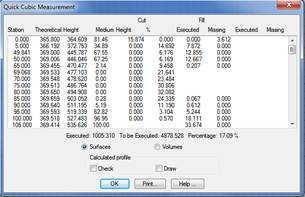
The following is an example of the list. A description of the characteristics of each of the columns appears below:
Station: Station analyzed.
Theoretical Height: Height that should be reached when executing the works at the previous station.
Height: Height of the current terrain.
Executed: Surface or volume executed according to the previous height.
Pending: Surface or volume pending execution.
All these values are indicated for cutting and fills. The end of the list displays the amount of square or cubic (volume) meters executed and pending, along with the survey percentage completed.
One can specify that the results displayed on the list should be expressed in surface or volume units.
Additionally, the list also contains a series of controls whose features are described below:
Print: It sends the list to the system printer or a text file.
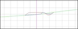
After validating the list, it is possible to draw the segment selected with the cross-sections of the current state of the terrain created from the selected points.