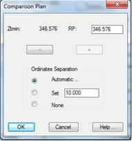
This option controls the representation of both the comparison plan and separation in ordinates. When this button is clicked, the following window is displayed, which is described below:
Comparison Plan: MDT proposes the comparison plan’s height (it can be seen with the text Ztmin) by default. Its height can be changed by using the + or - buttons. The height increases or decreases when these buttons are clicked are directly related to the vertical scale selected on the numerical data.
Ordinate Separation: This control sets the separation of ordinates or, in other words, terrain height marks. Three different options exist:
Automatic: Depending on the drawing’s scale, the program sets a suitable separation.
Fixed: The interval with which the terrain heights should be represented is set.
None: No information is displayed on terrain height ordinates.
Settings
Clicking on this tab accesses the settings for the longitudinal profile, where, among other parameters, we can change the style of the presentation of the numerical data from among the different styles available. Consult the Customization Manual for further details.