The purpose of this command is to create a longitudinal profile file with the extension .LON that has not been obtained from the Digital Terrain Model, with the cross-section profile horizontal alignment position corresponding to the same horizontal alignment or polyline, given that the interpolation of this point gives unequal or incomplete interpolation values.
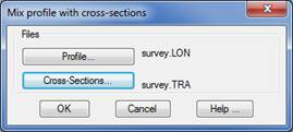
With the following window select the longitudinal file and cross-section to merge.
Last, the two files are merged, completing the horizontal alignment vertexes for each cross-section profile for the stations at which the height information is not defined, first modifying the selection then renaming the original with the extension .BAK.