This option will enable us to import piping networks from other formats, gradually incorporating new formats. The option of importing the LandXML, JSON and SEG (TcpMDT Segment) formats is currently supported.
On executing the command, the program will ask for the file to be imported and can be filtered by extension in accordance with the formats available. Once the file has been read, both the nodes and the sections of piping will be drawn automatically.
If you select a point file, pun extension, you can specify the depth of the node in the Point code:
1 1000 1000 100 Z99.58 (the height of vertical alignment would be 99.58) .
1 1000 1000 100 D-1.244 (the depth of the node would be 1.244).
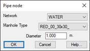
Network: Type of Network to create.
Manhole Type: Block to insert in each of the nodes of the pipe.
Diameter: Width of each of the wells to be inserted.
In the case of selecting a segment file, a node will be created at each vertex of the vertical aligment, taking the height terrain of longitudinal profile and as the height of the node, the height of the vertical aligment. The depth shall correspond to the difference between the height terrain and the height of vertical alignment.
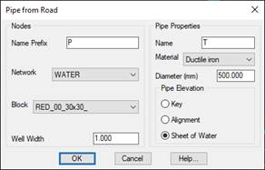
Nodes
Name Prefix: Nodes are automatically numbered, text to be inserted as a prefix to the number.
Network: Type of network into which nodes will be inserted.
Block: Block to be represented in the insertion of each of the nodes.
Well Width: Well width of each node.
Pipe Properties
Name: Name of the pipe section to be created.
Material: Material of the pipe section to be created.
Diameter: Diameter of the pipe section.
Pipe elevation: We indicate the position of the height of vertical alignment, the options would be:
· Key
· Aligment
· Sheet of water