With these controls we can create a new vertical alignment, add an existing file or save the changes of the alignment in edition:
New: Creates a new vertical alignment. It will ask for a file path for the new vertical alignment and it will set the new blank file as the active one.
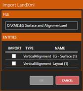
Open: Asks for a ras, lon or LandXML file and adds it to the panel and the CAD view. In case of importing a vertical alignment from a LandXML file that has more than one vertical alignment, the following dialog will be shown so that we can choose the desired alignment:
Once we click ok, the application will ask for a path for the imported ras file and it will be stablished as the active one.
Save: If there’s an alignment active, by default it will ask for a path to store a new ras or LandXML file with the current alignment’s data: if it has been modified the changes will be stored, otherwise it will be an exact copy from the original. If the output’s file extension is changed, or there’s no active alignment when the button is clicked, the following options will be presented:
·Save as dxf: Saves the current drawing in the CAD view in a dxf file. This includes polylines and measures drawn by the user.
·Save as jpg: Allow us to store a georeferenced screenshot of what is currently visible in the CAD view. To adjust the screenshot settings the following dialog will be shown: