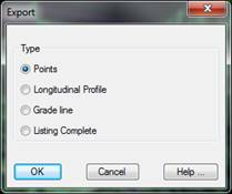
When selecting the Export option, the program presents us with a new dialogue in which different forms of exporting data are presented. The dialogue is shown below and its characteristics:
Points: The coordinates of all the points on the list are exported to a points file. When validating the dialogue, the command Export Points will be executed automatically. For further detail consult the Topographical Points section.
Longitudinal Profile: Possibility of creating a longitudinal profile from the information obtained in the points' analysis.
Grade line: The same as in the previous case above, in this case a grade line would be generated.
Full Report: Dumps all the content of the list in an ASCII file in such a way that it can be edited or handled with any word processor.