This function enables us to calculate and display, using the commands of the CAD environment, the height of any predetermined flat coordinate point (2D) on a given surface represented by a triangular grid. Hence, each time we click on a point within the horizontal projection of a grid corresponding to a surface, its corresponding point coordinates are shown: the predetermined abscissa and ordinate, predetermined, and the height calculated for this position on the surface.
In addition, if the uncertainties in relation to the point coordinates of the vertices of the corresponding grid are ascertained using the laws of propagation of variances and covariances, the uncertainty associated with the height of this flat position on the surface is estimated and displayed.
The method used to determine the height of points on a triangular grid consists of an algorithm which calculates the height of the point in question as a weighted average of the heights corresponding to the three vertices of the triangle in the grid containing the planimetric position predetermined by the user and the said weighting is based on criteria of a geometric nature. This relational model for calculating the height is subject to the law of propagation of variances and covariances to estimate the uncertainty or error in relation to the height.
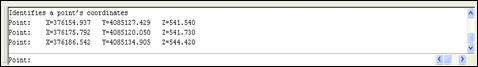
Each time the screen is clicked with the mouse, the AutoCAD command line shows the coordinates (X, Y and Z) of the point. Should the area outside the area defined by the surface be clicked, the X coordinate appears as Indeterminate.