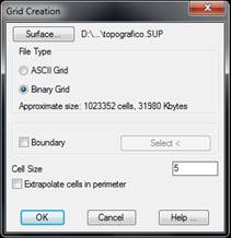
This tool allows us to create a grid file from a surface.
By clicking the Surface button, one can choose a surface other than the current drawing. In File type, one has to specify the type of grid to be created: either ASCII Grid or Binary Grid. When one or other option is selected, the approximate size of the file to be created is displayed.
The possibility of specifying a Boundary exists by designating a closed polyline with the Select button. In this way, the grid would then be defined only within the boundary polyline. This check makes the grid creation process slower, and it is therefore not advisable for very dense grids.
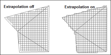
The option Extrapolate cells in perimeter is used to obtain grids with a larger surface.
Lastly, the Cell Size parameter determines the separation between grid coordinates. The smaller this value is, the denser the grid, and the file will occupy more space. However, if the grid is used to calculate volumes, the result will be more accurate. See volume calculation by Grid Difference in the Volumes section.
This command ends with the creation of the relevant file. To view the results, use the Maps > Draw Grid command.