18.1. Route by Terrain |
This tool allows you to make an interactive tour over a surface or mesh file that is set as the current surface/mesh in the drawing.
For terrain generation, the program uses predefined textures in the configuration. A more realistic result can be achieved by inserting a georeferenced image with the Images > Insert Image command. This is valid only for surfaces.
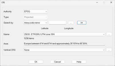
Before displaying the viewer, it is requested to select the coordinate system, in order to make the necessary calculations for some of the viewer's utilities such as the display of shadows.
Accepting the window launches the Viewer.
|
|