23.5. Import GPX |
This command allows you to render the contents of an XML file that follows the GPX standard, see GPX: the GPS Exchange Format (topografix.com). This type of file is used to exchange GPS data relating to waypoints, hiking routes, forest tracks, etc.
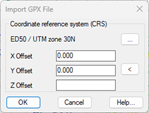
Once you have selected the XML file, a window appears in which you specify the coordinate system of the drawing. By default, the SRC of the drawing will be displayed, if you have it assigned.
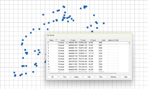
Next, the contents of the file are drawn, creating MDT points at the waypoints of the file, and drawing polylines with the routes.
|
|