18.10. Draw Visibility Map |
This command allows you to know the visible areas of a surface from one or more points of view. An image will be generated with different colors depending on whether the visibility of the area from the established observation points is possible.
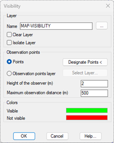
Layer: Layer on which the image representing the visibility zones is drawn.
Observation points.
Points: Selecting observation points with the Select Points button <.
Observation Points Layer: Selection of the layer in which the observation points are located. They must be MDT points.
In the case of selecting several observation points, a certain area is considered to be visible if it is visible from at least one of the selected points.
Observer height: Height from which visibility is calculated at each of the points.
Maximum observation distance: Maximum distance from the observation at each of the points.
Colors: The color of the image is set according to whether or not the area is visible. By clicking on the colored rectangles, you can change the selected color.

|
|