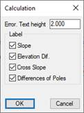
Settings related to the "Label Slopes and Elevation Difference" command and the default parameters used by this tool.
Error. Text Height (m): The height of text associated with the texts that are labeled and that are considered an error due to the constraints associated with the zone.
Label: Default selection of the texts to be labeled.
·Slope (%): Longitudinal slope of each of the trackers.
·Elevation Dif. (m): The difference in elevation between trackers.
·Cross Slope (%): Cross-slope between trackers.
·Difference of Poles (m): The difference in elevation of each pole with respect to the current surface.