ISO 19111, Geographic information – Referencing by coordinates, defines the conceptual scheme for the description of coordinate referencing, as well as the schema that describes the information required for coordinate change operations.
On the other hand, it also describes the data necessary to define coordinate reference systems, both those that do not vary over time and those in which the values of the coordinates change due to the movements of tectonic plates.
Based on this standard, the geodesy module includes the following types of coordinate reference frames:
Geographic 2D
Geographic 3D
Geocentric
Projected
Vertical
To perform the transformations and/or conversions of coordinates between two different systems, the program uses the library of geodesic transformations and cartographic projections PROJ. This library also includes the geodesic database of different authorities recognized worldwide, such as EPSG, ESRI, IGN France, etc.
Based on this library, the geodesy module provides tools to convert and/or transform coordinates individually, from a file or from a drawing.
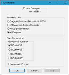
The geographic coordinate format is configurable and presents the following options for setting input and output settings:
The following formats are supported:
Degrees/Minutes/Seconds NS-EW e.g.: 36 40 34.564 N
+/-Degrees/Minutes/Seconds e.g.: -4 25 12.3424
+/-Degrees e.g.: -2.23541
where the degrees, minutes and seconds separator for the first two formats may be:
‘ ‘ Space
‘/’ Stroke
‘:’ Colon
‘ ° ‘ ‘’ ’ Degrees/Minutes/Seconds symbols. For minutes and seconds the symbol is just a single quotation mark and double quotation mark, respectively.
If the toggle Automatic Format is marked, the program will read any combination of these formats. This option is only available as a source or import format.
Also, it’s possible to set up two important features involved in the calculation process.
Promote CRS to 3D: If this checkbox is enabled, the program will try to find an equivalent 3D coordinate system for each 2D coordinate system selected for doing the calculation. It could be the source coordinate system, the target one or both coordinate systems.
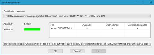
Manual selection of coordinate operations: By default, the program uses the set of coordinate operations which has the best accuracy for the calculation area. When checking this option, the program will show, in a list, all coordinate operations available to convert and/or transform from source coordinate system to target one, along with the accuracy (in meters) and the grid files (it they are using for calculation) of the coordinate operation set.
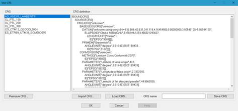
Apart from the coordinate reference systems available for each authority, the geodesy module allows one to define user coordinate systems in WKT format. To access to the screen which allows to manage this coordinate systems, the button User CRS… must be clicked.
On the left side of this screen, the list of available user CRS is displayed, and on right side, the WKT definition of the coordinate system selected from the list.
To edit an existing user coordinate system, simply select it from the list and manually modify its parameters in the CRS Definition edit box. Also, a new coordinate system can be created, entering manually its full definition, using the definition of an existing official coordinate system, selected using the Load CRS… button, or import it from file, clicking on Import CRS… button.
One way or another, the new CRS can be created or replaced by entering its name in CRS name edit box and clicking the Save CRS button.
To remove an existing coordinate system, it must be selected from the list and click Remove CRS… button.
|
Configuration of Coordinate Reference Systems
|
The different options presented by the program to perform the conversion and / or transformation of coordinates require a previous configuration of the parameters of the source and destination systems. The following window allows you to set the values of these parameters:
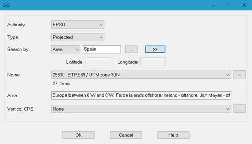
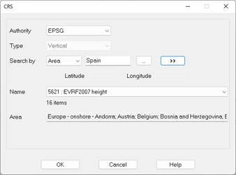
- Authority: Selects the authority that provides the geodesic database. The available options are: EPSG, ESRI, IGNF and USER. The selection of the latter one shows the list of the coordinate systems created by the user. For managing them, refer to the introduction of this chapter.
- Type: Indicates the type of SRC. It can be Geographic 2D, Geographic 3D, Geocentric or Projected.
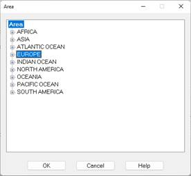
- Search by: Sets the search filter for coordinate systems. You can choose between Area, Code, Name and Location. For the latter, latitude and longitude must be entered in decimal degrees, between -90.0 and 90.0, for latitude, and -180.0 and 180.0, for longitude. In case of selecting the Area option, apart from manually entering the name, you can select from the list that is displayed by pressing the ellipsis button, to the right of the edit box:
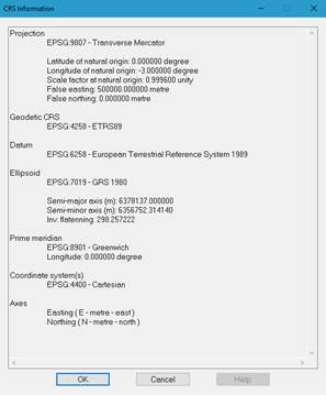
- Name: Displays the list of coordinate reference systems resulting from applying the parameters discussed above. The name of each system is composed of the code and description, separated by colon. The button on the right of this list allows one to show the details of the selected coordinate system.
- Area: Displays the usage area of the selected coordinate system.
- Vertical CRS: Allows you to select a geoid model for 2D and projected geographic systems.

 TcpMDT - Help