Allows the conversion and/or transformation of coordinates supplied in manual mode or read from file.
To perform the calculations, you must indicate the parameters for the source and destination reference systems (See section Configuration of Coordinate Systems), enter the coordinates, and press the buttons or, depending on the direction in which you want to perform the calculations.
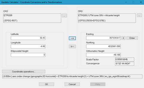
Once the conversion is done, the precision of the transformation, the operations performed and the grid files used will be displayed at the bottom of the screen.A button will be enabled to select the set of coordinate operations, if the geodesy module has been configured in this way.
Depending on the type of geodetic CRS set, the following names are displayed for the coordinate axes:
Geographic CRS
Latitude
Longitude
Geocentric CRS
X
Y
Z
Projected CRS
East
North
For geographic and projected CRS’s, Orthometric Altitude or Ellipsoidal Altitude will be displayed, depending on whether or not Vertical CRS has been selected.
For projected reference systems, Convergence of meridians, in degrees, minutes and seconds, and the Scale Factor are displayed as additional information. In addition, you can select coordinates from the drawing by clicking the < button, and draw calculated coordinates by clicking Draw…

 TcpMDT - Help