This option allows one to associate work data for future identifications. It is accessed through the Surveying > Survey Data command, or by clicking the Survey button within the Station Calculation section.
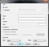
In the section CRS it should be indicated whether a Local coordinates systems should be applied or whether it is a Projected coordinate system. In this case, by pressing the button on the right the projection system and datum can be selected.
The fields Name, Site, Operator and Date are solely for information purposes.
The Corrections applicable in the calculation must also be established. The Sphericity and Refraction correction can be enabled for any type of coordinate system and Reduction to Ellipsoid and Combined Scale Factor, only if it is a projected CRS. If this latter correction is enabled, the Average Radius of the Earth in the survey area will also have to be introduced .
By default, the corrections enabled are copied in the Topography Configuration. See section for a full description of its indications and effects.
Finally, the Brand and Model of the instrument used must be selected to take into account its precisions in the calculations.