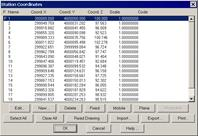
This option displays the each station’s current coordinates. It displays the following information for each station: type (“F” if fixed, blank if not), name, X,Y and Z coordinates, scale, and associated code.
Clicking the Edit button allows one to modify the properties of the station selected. One can create a new station and assign its coordinates, scale and code by clicking on New. Delete deletes the station’s coordinates, but without deleting it from the database.
This window allows multiple station selection. Several can be selected at the same time to modify their properties simultaneously. The Select All and Clear All buttons facilitate this task.
The Fixed and Mobile buttons mark and unmark the stations selected as fixed stations. The Projected button calculates the scale of the stations selected automatically from their coordinates, as long as one has specified that one wishes to work with a projection in the survey data. The data entered for the Survey is used to make the calculation. The Planes button assigns the value 1.0 to the scale of the stations selected.
Clicking the Read Drawing button captures all the station information represented in the original drawing. A station file can also be added using the Import button. Additionally, the Export button can save the information to a station file. Lastly, Print generates a station coordinates list with the following format: