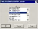
This option allows one to calculate stations that have target at least three known coordinate points. Its use is very similar to the Direct Intersection command. It can be accessed through the Surveying > Utilities > Inverse Intersection drop-down menu or by clicking the Inverse Intersection button from the Station Calculation screen. In the former case, it requests an instrument set-up to be selected:
Combinations are calculated three by three with this method, automatically deleting the badly conditioned ones that lead to the “Dangerous Circle” case.
If the Goodness-of-fit tests have been activated under the Least Squares option within the topography configuration, the Results frame will be shown if the Chi-Square test has been passed or not. Furthermore, in the lists of distance, azimuth, angular and vertical observations, a column is added with the reliability level resulting from the Baarda test. In this case the values may be: perfect, good, poor, bad or incorrect.
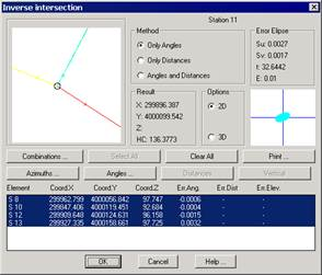
Furthermore, the results also include the Horizontal Correction which will be assigned automatically to the positioning used. The results have the same structure in sections with the following format:
INVERSE INTERSECTION CONTROL STATIONS
Element
X Coord.
Y Coord.
Z Coord.
Ang. Error
Dist. Error
Height Error
E 5
299989.317
4000035.758
100.746
0.0000
0.013
-0.002
E 2
299949.759
4000031.202
97.563
-0.0000
0.025
-0.000
E 11
299896.356
4000099.534
94.348
0.0147
-0.040
-0.004
E 10
299847.406
4000119.451
92.684
-0.0129
-0.006
0.007
RESULTS
Planimetric Adjustment
Calculation by Angles and Distances
Solve: X: 299962.795 Y: 4000056.828 CH: 142.7377
Standard Deviation: X: 0.0033 Y: 0.0037
Ellipse Error: Su: 0.0109 Sv: 0.0085 Orientation: 366.3611