Standard ISO 19111, Geographic information – Spatial referencing by coordinates, defines the conceptual scheme for the description of spatial referencing by coordinates. It describes the data necessary to define coordinate reference systems of one, two and three dimensions and the information necessary to convert coordinates from one system to another.
Under this Standard, a coordinate reference system consists of a coordinate system and a datum. Of the different types of datums distinguished by the Standard, Geodetic Datums and Vertical Datums are the ones which will be used in this module. The former require a description of an Ellipsoid and the latter do not.
Based on this classification, two groups of coordinate reference system have been created: Geodetic CRS’s and Vertical CRS’s.
Geodetic CRS’s are, in turn, divided into diverse types. Based on the classification of Standard ISO 19111 and on the classification made by the EPSG (European Petroleum Survey Group, www.epsg.org, now OGP, International Association of Oil & Gas Producers) on its database, the following will be distinguished: Geographic CRS’s, Geocentric CRS’s and Projected CRS’s.
Therefore, the 4 groups of coordinate reference systems we will be dealing with are:
Geographic CRS’s
Geocentric CRS’s
Projected CRS’s
Vertical CRS’s
To transform coordinates from one system to another it is necessary to know the parameters for the transformation of both systems to a common system, namely the WGS-84. Given that two types of datums are distinguished, geodetic and vertical, we will be talking about geodetic datum transformations and vertical datum transformations, which will be discussed in the following sections.
All the information, except user information, handled by the application regarding coordinate reference systems, datums, datum transformations, etc., from the different countries around the world come from the EPSG database, in version 7.9 dated August 17th 2011.
Coordinate conversions and transformations are performed with the cartographic projections library PROJ.4 v. 4.8.0 (trac.osgeo.org/proj) dated March 6th 2012.
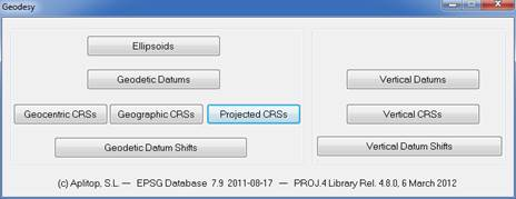
Management of the different elements comprising the geodesy module is done using the options displayed in the following window:
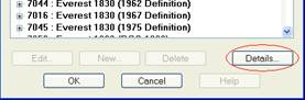
The information presented can be extended using the Details… button which appears at the bottom of the management screens. This button opens the official online help website of the EPSG database.
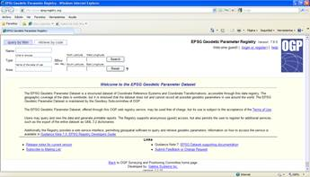
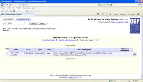
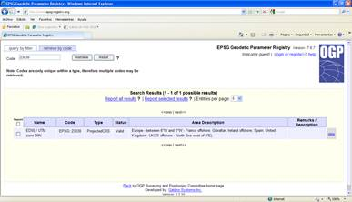
To make the query by code, you must click the link, Retrieve by code, which appears at the top left corner of the page, enter the code in the Code box, and click the Retrieve button.
To consult by code, the link Retrieve by code must be pressed which appears in the upper left-hand corner of the page, enter code in the Code box and press the Retrieve button.
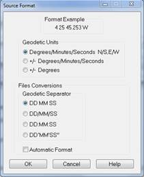
The frame Geographic Coordinates Format has options for setting the input and output configuration for this type of coordinates.
The following formats are supported:
Degrees/Minutes/Seconds NS-EW e.g.: 36 40 34.564 N
+/-Degrees/Minutes/Seconds e.g.: -4 25 12.3424
+/-Degrees e.g.: -2.23541
where the degrees, minutes and seconds separator for the first two formats may be:
‘ ‘ Space
‘/’ Stroke
‘:’ Colon
‘ ° ‘ ‘’ ’ Degrees/Minutes/Seconds symbols. For minutes and seconds the symbol is a just single quotation marks and double quotation marks, respectively.
If the toggle Automatic Format is marked, the program will read any combination of these formats. This option is only available as a source or import format.
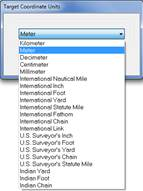
Another configurable element of the geodesy module are the projected and geocentric coordinates. The frame Coordinates Units allows the values to be set for the input and output data. The following window shows the units supported: