To execute this command there must be a representation of the longitudinal profile on the drawing. The program asks for the graphic selection of the longitudinal profile terrain. It then asks us to select the gradient file extension .RAS. Once selected, it will be graphically incorporated into the longitudinal profile into its corresponding elevation.
If the grade line has any curve defined, both the information associated with the curves as well as the input and output tangents will be drawn automatically.
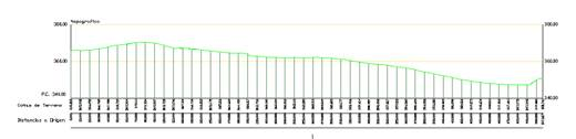
Longitudinal profile before importing the gradient:
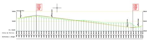
Longitudinal profile with the imported gradient:
|
Converting Grade Lines from Polylines 
|
Before selecting this command, the longitudinal reference profile needs to be represented in the current drawing on a continuous basis, or in other words, without being split into sheets.
When first executing this command, the program will ask what type of grade line is to be used, or in other words, if the grade line is of the parabolic or circular type. MDT will then ask for the terrain of the longitudinal profile in which the grade line has been defined, and finally we select the polyline to define the grade line. Once the command has been executed, the information on the grade line will be saved in the polyline entity, which can now be used with any of the commands in this chapter.
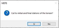
Furthermore, if the polyline defined for the grade line exceeds the longitudinal limits both at the start and at the end, the following message will appear asking if we want the grade line to be cut to the length of the longitudinal profile in which it has been defined.
Once the polyline has been converted to a grade line, this list of alignments should be stored in a separate file, although we can conduct a process to agree upon the vertices using the Compare Grade Levels option at a later date.
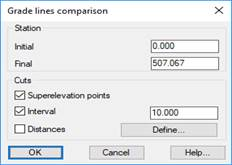
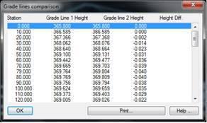
This command will allow us to obtain a list in which two previously selected grade lines are compared. On executing this option, the following window will appear in which to define the criteria pursuant to which we wish to compile the list:
Initial Station: The initial station from which the comparison list will be compiled.
Final Station: The final station from which the comparison list will be compiled.
Superelevation points: Enabling this option will include the vertices of each of the grade lines selected in the comparison list.
Interval: Interval at which the list is executed.
Distances: In addition, if we wish to compare certain stations on the grade line, we can insert the desired stations using this option by clicking on the “Define” button.
The corresponding list will appear once the dialogue box has been validated, featuring the option of printing out the list with the different printing options provided by the application, which we will deal with in due course.