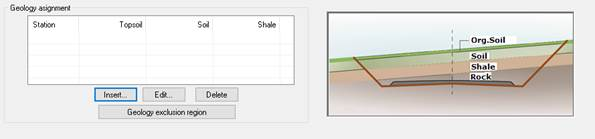
The different thicknesses of the geology of the natural terrain are defined in this section. Currently, up to four different strata types are supported:
1. Org.Soil
2. Soil
3. Shale
4. Rock
For each one there are two options:
1. Thickness: In this case the parallel layers of land are considered, for this you enter a value in meters that represent the thickness.
2. Cross section: Option to select a cross section file that represents the terrain in question, whether it’s the organic soil, transit or rock.
To the right of the panel is a drawing representing the distribution of each strata of terrain.
On the left is the definition of these by station, indicating up to which station it is defined and the thickness of each one:
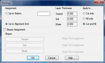
Insert – Edit: In both these options, the one for inserting a new element and the other to edit an existing one, the following dialog box appears to specify the terrain characteristics up to a particular station.
Assignment: This is to specify up to which station we are going to apply the defined geology type.
Layer Thickness: You establish the thicknesses of the different types of terrain that make up the section. As indicated above, a fixed thickness or a cross section file can be indicated.
Layer Thickness: The thickness of the different types of terrain comprising the section are set. This value will be used in the assignment of cutting slopes to specify the type of slope assignment.
Assign Slopes: This option enables us to conduct a rapid assignment of the slope for each of the types of geology defined.
Clicking on the corresponding tab will assign the slope to this layer of terrain. Once the assignment of geology has been completed and the dialog box validated, the corresponding cutting slope will be assigned automatically.
Delete: Deletes the selected assignment.
Geology exclusion region: This option enables us to specify a given area of the cartography affecting our road, at which we do not wish any geology calculation to be conducted.
As such, we need to draw one or more closed polylines in the areas we wish to exclude from the calculation, and once we have drawn these polylines we click on this button and draw the said polylines. The program will automatically consider these regions as areas in which the specified vegetal soil thickness will not be applied.