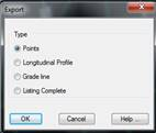
When the Export option is selected, the program displays a new dialog box with different ways of exporting the data. The dialog box and a description of its characteristics appear below:
Points File: All the coordinates of all the points on the list are exported to a points file. When the dialog box is validated, the Export Points command is automatically executed. For further details, see the Surveying Points section.
Longitudinal profile: Creates a longitudinal profile from the information in the list generated.
Slope: Similar to the previous option, only in this case it creates a slope without curves.
Full report: This option transfers the complete list to a text file.