Elements Library – Saving Ditches |
In this option we define two types of elements we will be working with in the templates:
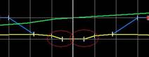
Elements of Median: Available for templates with medians, these are the interior median ditches, connected at the platform's interior vertex on both sides. The image shows the position.
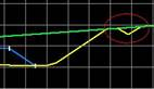
Saving Ditches: These are ditches existing either at the crown or foot of the slope, generally used to channel water. The image demonstrates its application.
|
Elements of Median
|
Saving Ditch
|
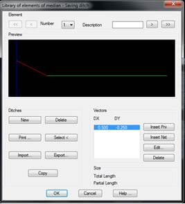
When the command is executed, a window is displayed to create, modify or delete the different ditches the program is working with by default. The elements defined in these libraries will be added by default when the template file is created.
There are three sections:
Element: Buttons for moving forward and backward across the entire library of defined ditches.
Elements: Set of buttons for defining or deleting the existing ditches.
New: Creates a new ditch.
Delete: Eliminates the current ditch.
Print: Prints the list of ditches with their vectors.
Select: Enables graphically selecting a ditch which has been previously drawn with an AutoCAD polyline.
Import: Imports the ditches from a file.
Export: Exports the ditches from a file.
Copy: Copies the current ditch to a new file.
Vectors: Set of vectors comprising the ditch, with the corresponding buttons for inserting, editing and deleting them.
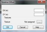
When any of these vector-editing buttons is selected (Insert Prv., Insert Nxt., Edit ) the following window is displayed for specifying the X and Y displacement that the vector the ditch being edited will have.
It is important to highlight that the value of the X increment cannot be zero or negative. In other words, vectors always have to travel away from the horizontal alignment. Should a vertical jump need to be entered, a small value can be entered (such as 0.01 or 0.001), which will have practically no effect on the calculations.
In the Textures, the texture associated to each of the vectors can optionally be set This option is used to give a more realistic appearance to the 3D representation commands available in the Maps option. If textures are not assigned, the program will automatically apply a texture when the above-mentioned commands are executed.