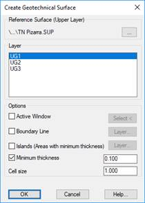
This command allows you to create a regular mesh that represents the upper part of a geotechnical layer, from a higher surface, and the depth data of the layer included in the points.
Similar to the Create Surface command, you can specify an Active Window or a Boundary Line that pinpoints the area that will cover the surface. The Islands work differently, instead of making holes in the surface, what is achieved is that the depth within the islands is what is specified as Minimumthickness, which can be zero. Finally, you must enter the cell dimension of the mesh to be created.
Once the calculation has been done, the program will request a destination file in which to save the result.