This command allows the conversion and / or transformation of coordinates stored in ASCII files, with different formats, and GPX (GPS eXchange Format), KML (Keyhole Markup Language) and W84 (file of geographical coordinates of the TcpGPS application).
In the case of GPXfiles, points(waypoints),routes(tracks)and routes(routes)areanalyzed. For KML,the analyzed tags are <Point>,<LinearRing>,<LineString>, and <Polygon>.
When you select a W84, GPX, or KMLfile, the WGS84 geographic coordinate system is set at the source.
For ASCII files, the supported formats are as follows:
n x y z
n x y
n,x,y,z
n,x,y
n;x;y;z
n;x;y
where
n: Number or name of the coordinate tuple.
x and z: components of the coordinate tuple.
Coordinates can be projected, geocentric or geographical. The correspondence of each element of the tuple according to the type of coordinates is:
Projected
x: East
and: North
z: Orthometric or ellipsoidal altitude
Geocéntricas
x: X
and: Y
from: Z
Geographical
x : Latitude
and : Length
z : Orthometric or ellipsoidal altitude
Space as a field separator is not allowed for this type of coordinates.
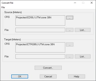
To perform the coordinate conversion, the properties of the source and destination systems must be initially set (see Section Configuration of Coordinate Systems). To do this, you must press the button to the right of the corresponding  SRC box. As you can see in the next window, the Source and Destination frames also show the type of coordinate units.
Then, at the bottom of each section, you must select the source file, which contains the coordinates to be converted and can have any extension, and the destination file, which will be created with the new TXT or PUNcoordinates andextension. It should be noted that all existing information in the latter will be deleted.
Once all the parameters have been set, press the Convert... to start the process.
At any time you can stop the process by pressing the Cancelbutton.
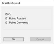
The number of points in the target file will be as indicated on the Converted Points line.
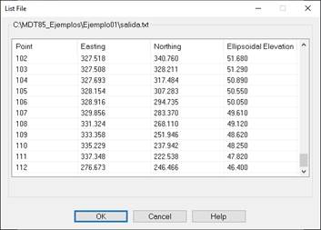
Once the conversion is done, you can view the file by clicking the List button... , an option that is also available for source data, except for GPX and KMLfiles.