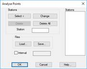
It is necessary to have a longitudinal terrain profile with an associated grade line on screen to use this command. The program requests a grade line to be selected in Graphic or File fashion. The following dialog box is then displayed, whose characteristics are described below.
Select: One graphically selects on the profile the stations from which information is to be obtained.
Change: Changes the station selected from the list for the one entered in the Station box.
Delete: Deletes the station from the list.
Delete All: Reinitiates the list, which then becomes completely empty.
Load: It is possible to load any file containing a station in its first column, so that the list is filled in automatically.
Save: Once all the stations are entered, the information on the stations can be saved on a file using this option.
Interval: Additionally, it is possible to set a specific interval to obtain the list. This option does not exclude the aforementioned options.
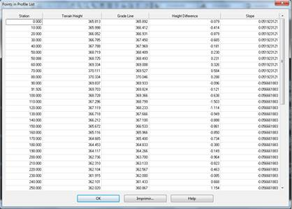
Lastly, the program displays a dialog box containing the information about the corresponding grade line projected orthogonally on the terrain, its corresponding height on the terrain (Terrain Height), the height of the grade line used for the calculation (Grade Line), as well as the difference between both along with its sign (Height Difference), depending on whether it is a fill (+) or a cutting (-).
These results can be printed or exported to an ASCII file or to a Microsoft Excel worksheet.