We use this command to smooth a grid by reducing the presence of unwanted peaks and the roughness of the terrain. The program requests a grid file, displays the size of the cell on the command line and asks for two parameters:
Radius: What radius of distance do we need to change a vertex. For example, for a grid with a cell size of one meter: a radius of one meter assumes that each vertex in the grid is smoothed pursuant to all the sizes of the four cells it comprises.
Iterations: The number of passes that need to be made. The grid from the previous step is smoothed again using the same radius in each iteration.
On conclusion of the smoothing process, the program will ask for the path in which we intend to store the new smooth grid and will report how many vertices in the grid have been changed, in addition to the maximum and average elevation displacement produced.
Removing spikes
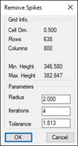
This command enables us to correct a grid by changing vertices that create spikes in it. On executing the command, we will need to locate a grid file and the following dialogue box will appear once it has been selected:
First of all, we will see the following for the purpose of reference: the size of the cell and the grid and the range of heights. The following three parameters can be adjusted to conduct this process:
Radius: Defines the maximum area occupied by the spike. In the case of spikes formed by a single vertex, a radius equivalent to the size of the cell will suffice, however in other cases it will need to be adjusted in accordance with the size of the area to be cleaned up. The program will suggest a size of four cells by default.
Iterations: The number of times the process is repeated. The removal process will always be repeated several times on the result of the previous iteration. As such, having previously corrected the grid, the vertices detected as spikes will tend to further reduce the height, as each pass in their environment (in the case of spikes formed by more than one vertex) has changed the heights. This parameter should be proportional to the radius to ensure the spike areas are cleaned up to the greatest extent possible. The program will propose four iterations by default.
Tolerance: Defines the minimum difference in height in order to regard a vertex as a spike, when comparing the height of the same with the dimensions of its surroundings (delimited by the radius). By default, the program will propose that all dimensions over 10% of the distance between the minimum height and the average height of the grid are regarded as spikes.
On conclusion of the command, it will specify the number of vertices that have been changed (spikes removed) and will ask for the route of the resulting grid file.
Filling holes
This command is designed to interpolate heights of holes (islands) in a grid. In order for the hole to be filled, the grid needs to have a closed contour line, in other words, all the vertices of the hole must have dimensions in the four directions (left, up, right and down).
The command will ask for a grid file and at the end of the process it will ask for the route of the resulting grid and indicate the number of vertices that have been changed (not necessarily equivalent to the number of holes. It is the number of vertices to which we have been able to assign a height, a hole can be made up of several vertices).
Delete Area
This command can be used to create an island, an area with no information on height, in a grid file. Once the grid file to be changed has been selected, the program will ask for a polyline, and after removing all the dimensions inside the polyline, it will ask the user for the file in which to save the change, which may be the same initial file or a different one.