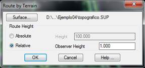
This tool allows one to take an interactive tour simulation on a surface or grid file. The following dialog box is displayed:
By clicking the Surface button, one can choose a surface or grid other than the current drawing. Concerning the observer’s height, one can choose between Absolute height throughout the tour or Relative height with regard to the surface height in each position.
To generate the route by terrain, the program employs a predefined texture configuration. A more realistic result can be obtained by inserting a georeference image with the Insert Image command this options is only with surface file.