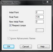
This command allows one to modify totally or partially the numeric order of the points represented in the drawing.
The program displays a dialog box containing the following elements:
Initial Point: Name of the first point one wishes to renumber. This point should be defined, otherwise the program will issue the warning “ERROR: Initial point not found”.
Final Point: Name of the final point up o which one wishes to perform the increment.
New Initial Point: Point number one wishes the first point requested will acquire. It should be equal to or greater than 1.
Respect Jumps: Allows one to indicate whether the numbering should be done respecting any possible jumps or increments of more than one point among various or if, on the contrary, all the points from the initial point should be numbered sequentially.
Increment: When the respect jumps option is deactivated, an increment can be entered that will be successively applied to each point. The points therefore can be renumbered, for instance, ten at a time.
Ignore Alphanumeric Names This possibility is enabled when there are point having a name that is not numerical. By activating it, those points will not be modified.
Along with Import Points and Export Points, this command is very useful to combine various jobs into a single job.
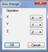
This command enables us to change the coordinates of the points or polylines selected. This is particularly useful for altering projects it is normally not possible to execute using MDT, for example, very steep slopes, tunnels, etc.
There are two ways of executing the command: selecting the polylines or a points file.
Selecting Polylines: The default option, whereby executing the command enables us to draw a graph of all the polylines whose coordinates we are going to change. Once concluded the following window appears in which the changes to be executed are inserted:
In this case, for example, the X column becomes the Y column, Y becomes X multiplied by (-1) and the Z coordinate remains the same.
The polylines selected will be redrawn on validating the window.
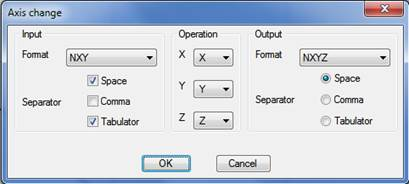
Selecting a file: In this case the change applies to a points file. The following window will appear on selecting this option:
Input: We specify the format of the file used to change the coordinates.
Operation: as in the previous case, we specify the correspondence between the current coordinate and the coordenate to be inserted.
Output: Format of the output file.
On validating this window the command will first ask for the points file in which we are going to change the axes, and then a new file to store the new coordinates once the changes have been made.