The project window allows one to have an overview of the files generated by MDT during the course of the project. The files a grouped together by categories according to the type of information they contain. Both the categories as well as the files they contain have contextual menus that are displayed when they are clicked with the mouse’s right-hand button. They allow MDT commands to be executed.
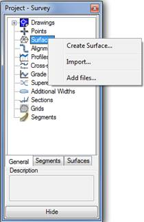
Project window with the Surfaces category menu
All the categories are displayed by default. By clicking on Segments or Surfaces one can ensure that only the files in one of these two categories are displayed. All the files are displayed once again when General is clicked.
Once can type in a Description for each file included in the project. One merely has to select the file from the list in order to edit it in the lower part of the window.
The Hide button means that the window will be resized, so that it occupies less space on screen. It returns to its previous state when View is clicked. Additionally, each time an CAD command is executed, the project window automatically disappears and is displayed once again when the command finishes.
A description has been provided below of each of the categories as well as of the operations or commands that can be executed at each of them.
For each of the files associated with each category there will be three common operations:
1. Delete: Eliminates the file from the project and, optionally, from the computer.
2. Copy: This allows the carrying out of a file duplicate.
3. Rename: Tool for changing the file name.
4. Add Files: This allows us to add the specified file to the project.
Each of the categories and files related with the project have their own associated commands which are listed below and are described in detail in their respective sections.
Points: Points files associated with the project.
Associated operations:
|
Category
|
Action
|
|
Import
|
Import
|
|
Export
|
Check
|
|
List
|
|
Surfaces: Surfaces files associated with the project.
Associated operations:
|
Category
|
Action
|
|
Create Surface
|
Set as Current
|
|
Import
|
Draw
|
|
|
Represent As
|
|
|
View
|
|
|
Information
|
|
|
Draw contours
|
|
|
Create grid
|
|
|
Export
|
Alignments: Horizontal alignment files associated with the project.
Associated operations:
|
Category
|
Files
|
|
Convert Polyline
|
Edit
|
|
Alignment Input
|
Check
|
|
Import
|
Draw
|
|
Draw Alignments
|
Dimension
|
|
Dimension Alignments
|
Locate
|
|
Delete Dimensioning
|
List
|
|
|
List by interval
|
|
|
Convert
|
|
|
Get Longitudinal Profile
|
|
|
Get Cross Sections
|
|
|
Generate Widenings
|
|
|
Generate Superelevations
|
Profiles: Longitudinal profile files associated with the project.
Associated operations:
|
Category
|
Files
|
|
Get Profile
|
List
|
|
Get Profile by Regression
|
Check
|
|
Profile Input
|
Draw Simple Profile
|
|
Convert Drawing Profile
|
Update
|
|
Convert from 3D Polyline
|
|
|
Import
|
|
|
Get multiple Profiles
|
|
Cross sections: Cross sections files associated with the project.
Associated operations:
|
Category
|
Files
|
|
Obtain Profile
|
List
|
|
Import
|
Check
|
|
Obtain multiple Profiles
|
Draw
|
|
|
Update
|
Gradients: Gradients files associated with the project.
Associated operations:
|
Category
|
Files
|
|
Convert Grade line from Polyline
|
List
|
|
Define Grade Line
|
Check
|
|
Import
|
Draw Compound Profile
|
Superelevations: Superelevation files associated with the project.
Associated operations:
|
Category
|
Files
|
|
Generate Superelevation
|
List
|
|
|
Check
|
Widenings: Widenings files associated with the project.
Associated operations:
|
Category
|
Files
|
|
Generate Widenings
|
List
|
|
|
Draw
|
Templates: Templates files associated with the project.
Associated operations:
Grids : Grid files associated with the project.
Associated operations:
|
Category
|
Files
|
|
Create Grid from Surface
|
Draw
|
|
Read Drawing Mesh
|
Draw Heights Map
|
|
Import
|
|
Segments : Segment files associated with the project.
Associated operations:
|
Category
|
Files
|
|
New Segment
|
Define/Edit
|
|
|
List Profile
|
|
|
Draw Compound Profile
|
|
|
Draw Cross sections
|
|
|
Generate Modified Terrain
|
|
|
Get Modified Terrain
|
|
|
Cubic Measurement List
|