The merging process allows one to include another surface within the current surface. It is equivalent Delete Area with the boundary of the surface included and then copies its triangles onto the current surface. In order to ensure the result is correct, heights at the perimeter of the surface to be included should coincide or be very close to the heights at the current surface’s the corresponding coordinates, otherwise inconsistencies will be produced in the digital model.
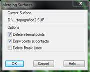
The program requests the file of the surface to be included and displays the following options:
·Delete Internal Points: Deletes the surveying points inside the area defined by the boundary of the surface to be included.
·Draw Points at Contacts: Creates surveying points corresponding to the vertices of the surface to be merged, as well as on the contact area between the two surfaces.
·Delete Break Lines: Cuts and/or deletes break lines within the boundary of the surface to be included. Should there be contour lines, they are also considered in this process.
There is the possibility of saving the result in a surface file other than the current one, enabling the Surface option and designating a file name.
Undo Operation
The Empty by Area, Obtaining Modified Terrain, Earthworks and Merge surfaces commands create an auxiliary file with the changes made in the drawing by the command itself. The Undo Operation command uses this information to restore the previous state of the drawing and the current surface.