The utility of this command lies in its ability to join any polylines whose end vertices coincide in a single polyline. This avoids having many broken polylines in the cartography, as well as making it possible to join sheets of digitalized cartography together.
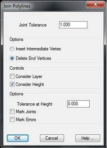
When the command is executed, the program request one to select polylines on which the algorithm to be applied. The following dialog box is then displayed, which is described further below.
Joint Tolerance: Represents the maximum distance that may exist between the end vertices of the polylines selected.
Consider Layer: If this control is activated, only polylines in the same layer will be joined.
Consider Height: If this control is activated, only polylines having the same height will be joined.
Insert Intermediate Vertices: When the polylines are joined, a new vertex will be created at the joints.
Delete End Vertices: The end vertices on the new polyline corresponding to the polylines to be joined are deleted in the new polyline.
Tolerance at Height: Represents the maximum height difference that may exist between two polylines which are to be joined. This option is available for the case of Consider Layer.
Mark Joints (only in the case of Consider Height): Any polylines which have been joined will be marked with a circle at the joint.
Mark Errors (only in the case of Consider Height): Any polylines which have not been joined due to height tolerance will be marked with a circle at the joint.
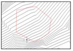
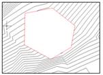
Cut Out Contour Lines
A gap within contour lines can be created by means of this command. The program requests a polyline to act as border of the cut and then the it eliminates all polyline segments to be found within the border. An example of this command in use can be seen in the image below.