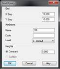
This command is used to quickly create a group of points. The initial window is for specifying the X and Y intervals of separation between the points, as well as the Name, Code and Level of the points being created. There are two possibilities for the elevation: a Constant elevation, or using the current surface to give the points their elevation. In the latter case, the grid points that do not project vertically over the surface are not created.
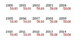
Once the parameters are validated the program requests the coordinates for a corner of the grid. Next, the second coordinate can be introduced, or, by typing “X” the direction of the X axis can be indicated, to create non-orthogonal grids. When the size of the grid is designated, the calculations of the number of points that are going to be created are displayed in the CAD status bar.
The points created are numbered successively, beginning in the first corner designated, and following the direction of the X axis.