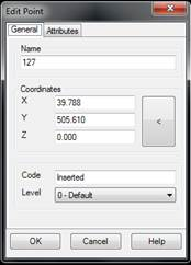
This option allows one to change surveying point attributes (ordinal number, code and level), and X, Y and Z coordinates. Other related commands include Points > Move to change their X, Y coordinates and Points > Change > Change Heights to change their heights.
The Edit Point window is displayed after a point is selected. It allows one to complete or change the point’s coordinates and attributes.
If the X, Y and Z coordinates are modified, the application moves the point to them and modifies the triangulation if necessary.
If a point’s name is changed, it should not coincide with another point’s name. Otherwise, the message “ERROR: Point name repeated" is displayed.
If level is changed, point visibility may vary depending on the configuration, as the program allows one to independently view the different levels’ attributes.
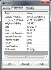
If the dialogue box features an Observation tab, the original data from the point reading, whether with a GPS or with the total station, is given therein.
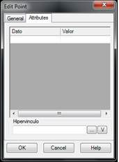
On the other hand, the Attributes tab allows for establishing additional information for the point, introducing the type of data and the value that this type takes in the edited point. There is a special attribute, Hyperlink that allows associating the point with a file link. The two buttons are used to modify the hyperlink and open the file with the associated application. This last operation can also be carried out with the command Points > Open Hyperlink.