With this command you can edit the plot properties, with the option for the user to modify them. After selecting the plot, the following dialogue box will appear:
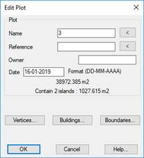
Name: Name associated with the plot, can have alphanumeric characters. There can not be two plots with the same name.
Reference: Normally this property is associated with the cadastral reference of the plot, in the case that you are working with cadastral parcels. In any case, the user can associate any information considered relevant with this attribute.
This field, in the case of containing information and is a string of 14 characters, will be considered as the cadastral reference of the plot for export purposes to the GML format.
: By pressing this button the user can graphically select the text that represents the name or reference of the plot, the corresponding field will be automatically filled in.
Owner: Attribute of the plot in which the user can enter the owner of the plot or any other relevant information.
Date: Date associated with the plot, this attribute is also used in the case of exporting the plot to GML format.
Area: Total area of the plot in the units specified in the configuration. In the case of the inner islands plot, the value of this area will be the result of the area of the plot minus the total area of all the islands it contains.
If you intend to export plots to be validated by the Cadastre of Spain, consult the following specifications on the GML cadastral parcel format.
Additionally, if the parcels contain islands, a line will appear indicating the number of islands and the total area of the islands.