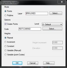
This command allows one to create break lines that are parallel to other break lines. It is very useful to define roads, pathways, streets, walls, etc., where only one edge has been measured and the parallel distance to another or others is known, in addition to the other edge’s relative or absolute height.
There are two ways of executing this command. In the Points mode, a polyline is drawn as with the Break Lines by Closest Point command and then a line parallel to it is created. In the Polyline mode, a polyline that has already been drawn is selected as a reference to create the parallel line.
In order to create the parallel polyline, the program first requests an orientation indicating a point to the left or to the right of the original polyline and then a distance to the reference polyline. Concerning height, one chooses among Repeat the original polylines heights, apply an Increment to them, use a Constant height, enter the height at each vertex in a Manual manner, or use the Point Codes as an increment for the original height in centimeters.
If the Create Points option has been activated, surveying points will be created at each of its vertices with the code selected in addition to the polyline being drawn.